
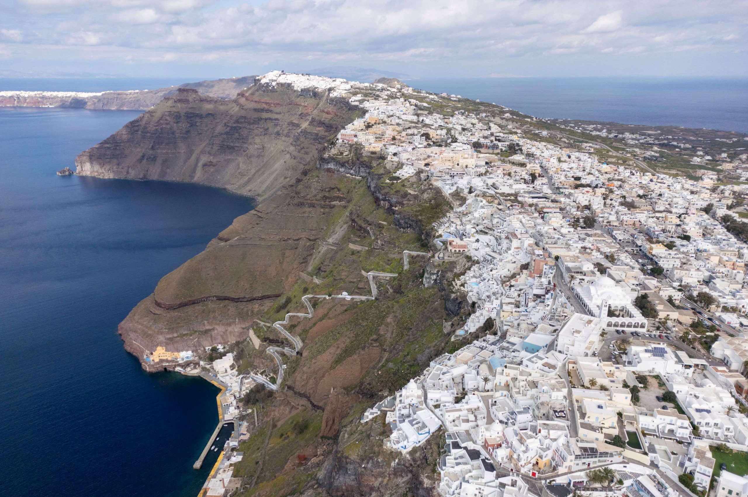
Scientific scrutiny continues to focus on Santorini, the renowned volcanic island in the southern Aegean, and the risks of landslides along its steep and porous cliffsides amid this past month’s “seismic swarm” in the region.
A team of researchers from the University of Athens’ department of geology and geo-environment, headed by Prof. Manolis Vassilakis, on Saturday conducted close range remote-sensing tests and measurements in order to try and pinpoint areas with higher risks for landslides.
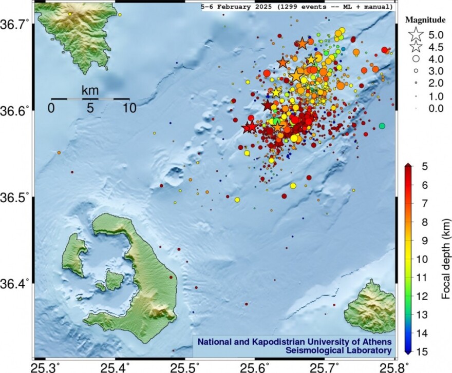
The new study is part of a series of initiatives by the university, officially called the National & Kapodistrian University of Athens, through an inter-disciplinary committee to manage risks and crises, which itself was recently established in the wake of the surging seismic activity in the southern Aegean.
The affected region lies in a maritime zone bordered by the islands Santorini (SW), Amorgos (NE), Ios (NW) and Anafi (SE), has yielded more than 10,000 quakes since late January 2024, including several moderate earthquakes measured above the magnitude of 5 on the Richter scale.
Both ground scanning equipment and UAVs equipped with hi-res cameras and LiDAR sensors are being used.
According to Vassilakis, who specializes in remote sensing and tectonic geomorphology, the study focuses on areas of high risk and where there is a strong human presence. Such areas are the quayside of Athinios, the old port, and the seaside sites of Ammoudi and Armeni, as well as the Korfos anchorage on the nearby small isle of Thirasia, which lies across (west) from arc-shaped Santorini proper in the iconic Caldera. The Thera volcano, now a small islet, lies between Santorini and Thirasia.
Source: Tovima.com
Latest News

Pope Francis: A Pontiff Who Reshaped the Papacy and Sparked a Global Conversation
His first words from the balcony of St. Peter’s Basilica—“Brothers and sisters, good evening”—set the tone for a pontificate that would challenge norms, favor mercy over dogma, and bring the papacy closer to the people.

When Blue Skies was Unmasked as ND’s Political ‘Slush Fund’
The fact that so many top New Democracy (ND) party cadres were paid by the firm Blue Skies, owned by Thomas Varvitsiotis and Yiannis Olympios, without ever citing this publicly, raises very serious moral issues, regardless of the legality

Greek Women’s Water Polo Team Top in the World after 13-9 Win Over Hungary
The Greek team had previously defeated another tournament favorite, the Netherlands, to reach the final.

S&P Raises Greek Rating; BBB with Stable Outlook
S&P’s decision raises the Greek economy to the second notch of investment grade ladder, at BBB with a stable outlook.
Greek Tourism Optimistic About Demand from American Market
A recent survey by MMGY Global, conducted from April 3–5 with a sample of 1,000 U.S. adults, found that 83% of Americans still intend to take leisure trips over the next 12 months, a slight drop from 87% in late February

New Exposé by Domumento Reveals Nefarious Triangular Link of ‘Black Money’ with New Democracy, Blue Skies, & Truth Team
The latest exposé by the Documentonews.gr news site lays bare what appears to be a surreptitious path of indirect financing of ND through the business sector—transactions that, as widely understood, rarely occur without expectations of reciprocal benefit

PM Meloni Meets Vice President Vance in Rome Signalling Optimism on Ukraine Talks
Meloni emphasized the strength and strategic value of the Italy-U.S. partnership.

Airbnb: Greece’s Short-Term Rentals Dip in March Amid Easter Shift
Data from analytics firm AirDNA shows that average occupancy for short-term rentals dropped to 45% in March, down from 49% the same month last year.

Easter Week in Greece: Holy Friday in Orthodoxy Today
At the Vespers service on Friday evening the image of Christ is removed from the Cross and wrapped in a white cloth

Meloni and Trump Meet in Washington, Vow to Strengthen Western Ties
“I am 100% sure there will be no problems reaching a deal on tariffs with the EU—none whatsoever,” Trump stressed.


![Πλημμύρες: Σημειώθηκαν σε επίπεδα ρεκόρ στην Ευρώπη το 2024 [γράφημα]](https://www.ot.gr/wp-content/uploads/2025/04/FLOOD_HUNGRY-90x90.jpg)


![Ξενοδοχεία: Μεγάλο το ενδιαφέρον για επενδύσεις στην Ελλάδα – Η θέση της Αθήνας [γραφήματα]](https://www.ot.gr/wp-content/uploads/2025/03/Athens-hotels-90x90.jpg)


![Airbnb: Πτωτικά κινήθηκε η ζήτηση τον Μάρτιο – Τι δείχνουν τα στοιχεία [γράφημα]](https://www.ot.gr/wp-content/uploads/2024/07/airbnb-gba8e58468_1280-1-90x90.jpg)


![Ξενοδοχεία: Μεγάλο το ενδιαφέρον για επενδύσεις στην Ελλάδα – Η θέση της Αθήνας [γραφήματα]](https://www.ot.gr/wp-content/uploads/2025/03/Athens-hotels-600x399.jpg)